Serwis wymaga plików cookies do prawidłowego działania strony. Korzystanie z serwisu bez zmiany ustawień dla plików cookies oznacza, że będą one zapisywane w pamięci urządzenia. Ustawienia te można zmieniać w przeglądarce internetowej.
The best Polish website dedicated to the Greek island Crete and to a small extent of continental Greece. You will find useful information related to visiting Crete that goes beyond the offer of optional tours. On the website you will also find descriptions of the most interesting places that we visited by visiting this largest Greek island. The content complements the current news, photographs and recipes of Greek cuisine.
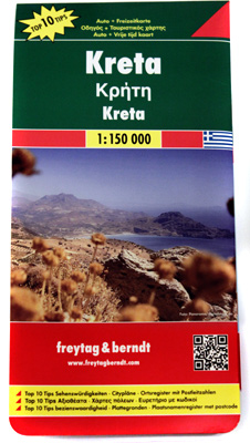
Crete map of the Freytag & Berndt publishing house
The Freytag & Berndt map is a classic map on a scale of 1: 150,000, printed on plain good paper. This results in the fact that in terms of physical functionality in comparison with competitors' products it will be very poor. The price for which it is offered, you can buy laminated maps with much longer life and ease of folding. A paper sheet, almost one meter wide and 85 cm high, may discourage the purchase of a large number of people. This is all the more important because the average map of Crete other publishing houses has an area smaller by half. However, we will try to draw your attention to this map, because, apart from not very beneficial physical properties, it is a really interesting cartographic item. Below we will present you with positive features that should definitely outweigh the balance in favor of the product of Freytag & Berndt.
The main advantage of this map of Crete is simplicity, which translates into high readability and ease of use. Unambiguous captions allow for easy and quick identification of locations even in those areas where the density of the places added is the largest.
One of the major advantages of this map is also the marking of scenic routes that have been highlighted in green. Looking from the perspective of several thousand kilometers, which we defeated on the Cretan roads, we must admit that these signs work well. Yes, in many other maps you will find markings for lookouts that have quite similar functions, but the distinction of road sections introduced by Freytag & Berndt is much more legible and predictable. This allows you to prepare the route in advance, taking into account the spectacular section of the road.
When planning a trip, it will also be very useful to clearly mark interesting places using clear pictograms. The most important attractions are highlighted in purple. There are markings, among others, archaeological sites, caves, castle ruins, windmills, churches and tourist hostels.
The network of roads depicted on the map reflects quite well the actual network of existing roads in Crete. This is partly due to the fact that the map is relatively fresh - the date of its publication is 2013 (the next update is expected in 2016). In addition to asphalt roads, some local gravels were also put on the map. In the case of such roads, the passability can be debatable and to a large extent depends on the capabilities of the car and the actual condition of the surface. Before using these types of roads, we recommend that you get more information from other sources or from the Cretans.
Jeden ze schematycznych planów miast
Ciekawym dodatkiem są mapki wykopalisk
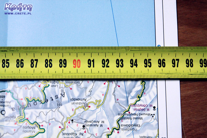
Na zdjęciu widzicie jedną z licznych tras widokowych naniesionych na mapę Freytag&Berndt
The biggest disadvantage of this map is its size. Kreta according to Freytag & Berndt is almost a square meter of paper.
As with other maps of Crete, here you can also find plans for several of the most important modern cities of Crete: Heraklion, Chania, Rethymno and Agios Nikolaos. Of course, these are rather indicative and schematic plans, but they will be enough for walking. The location of the most important museums, some monuments and other places important for tourists was placed there. An interesting supplement is the plans of the largest archaeological excavations, such as: Knossos, Malia, Zakros, Fajstos, and Agia Triada.
The map is also accompanied by a small book printed in several languages. This brochure contains brief descriptions of the 10 most important places additionally highlighted on the map, which according to the publisher is worth visiting in Crete. It is not a very important addition, but its main advantage is the town index.
Finally, our little summary. The Freytag & Berndt map is a great affection, because its previous edition has faithfully accompanied us during several previous trips. Despite such a long period of exploitation, it is difficult to remember the situation in which this map "lost" us in Crete. Even its gigantic dimensions sometimes proved to be an advantage, because often this map landed during a standstill under the windshield of the car, acting as a roller blind protecting the cabin from the sun :).
We hope that in the future this map will also appear in the laminated version, which in our opinion would significantly improve its usability. However, even in the current form of the issue, we strongly recommend you this map for clarity, ease of use and up-to-date data. We recommend !!
Data publikacji:
Data modyfikacji:
Średnia: 5
Liczba ocen: 1
0.5
1.0
1.5
2.0
2.5
3.0
3.5
4.0
4.5
5.0
Oceniłeś na:
Kreta informacje5 na
5 (0)
liczba ocen
1
Wszystkie treści i zdjęcia występujące w serwisie są naszą własnością.
Wykorzystanie ich w dowolnej formie wymaga pisemnej zgody autorów.
Freytag&Berndt ma grubo ponad 200 lat doświadczenia w kartografii i to widać po dokładności i przejrzystości tej mapy. Ale wytrzymała to ona rzeczywiście nie jest, po miesiącu spędzonym na Krecie w zimowej wilgoci rozeszła mi się definitywnie.
1
CRETE - Kreta
2015-06-14 17:55:04
komentarz z
Niestety wytrzymałość nie jest jej mocną stroną, ale to jedyna wada tej mapy. Nasz pierwszy egzemplarz przed kompletny "zgonem" i po kilku reanimacjach wyglądał jak poniżej:
http://www.crete.pl/zdjecia/o-crete-pl/crete_pl_mapa.jpg
1
Marzenna Kawecka
2015-06-14 18:04:56
komentarz z
Kretę można zwiedzać także komunikacją lokalną czyli autobusami Ktel. Jeśli nie przyjadą na czas nie ma co się denerwować przyjedzie na pewno może nawet dwa. Bardzo dbają o turystów. Jeśli na pierwszym przystanku jest już pełen zaraz podstawie ja drugi. No i jest tanio.
CRETE - Kreta
2015-06-14 18:21:16
komentarz z
Owszem jak najbardziej, sami też czasem korzystamy z KTELa i bardzo go sobie chwalimy. Pamiętaj jednak, że do wielu miejscowości autobusy nie dojeżdżają lub też kursy realizowane są bardzo rzadko. W takich przypadkach samochód, lub skuter są najlepszymi środkami lokomocji. I właśnie w tych wypadkach mapa okaże się nieoceniona
Ewa Hryniewicka
2015-06-14 18:15:04
komentarz z
Ja też korzystam z takiej mapy, bardzo precyzyjna
1
Olcia Sz
2015-06-14 18:41:48
komentarz z
Mój szerszen był boski.. mały biały Yaris. .. 1230 km w 5 dni.. mapa w dłoń. . I już !
1
CRETE - Kreta
2015-06-14 18:53:44
komentarz z
Piękny wynik :) (y). Pewnie widziałaś spory kawałek Krety. Które miejsca szczególnie zapadły Ci w pamięci? Skąd miałaś bazę wypadową?
Olcia Sz
2015-06-14 18:56:50
komentarz z
Z kalamaki 4 km od Xani.. byłam 11 raz!
1
Olcia Sz
2015-06-14 19:05:42
komentarz z
Zastanawiam się co się stało z wioska Dionysos Village w siti... pięknie wygląda ale cała pusta ... taka wielka budowla, prawie jak osiedle jakieś. ..
1
Olcia Sz
2015-06-14 19:10:37
komentarz z
A tak to Elafonosi, Falasarna, Vai... no i piękne miasta i urocze wioski.
Niestety homemade raki była zgubna, wszyscy się źle czuli po tym. Nie pamiętam miejsca ale zaraz za tunelem na wzgórzu w drodze na elafonisi...tam była jakaś jaskinia czy coś. .. poszukam na mapie i napisze
1
CRETE - Kreta
2015-06-14 19:18:09
komentarz z
Faktycznie zjeździłaś Kretę od jednego do drugiego krańca. Chyba poza miodowym raki wyjazd można uznać za bardzo udany? ;)
1
Olcia Sz
2015-06-14 21:05:21
komentarz z
Oczywiście. . Jak każdy! Odliczam do następnego!
Tomasz Wu
2015-06-14 20:34:07
komentarz z
Mam nadzieję, że zaktualizowana nawigacja samochodowa w zupełności wystarczy
CRETE - Kreta
2015-06-15 06:33:45
komentarz z
Nawigacja jest ok i doskonale sprawdza się w gąszczu jednokierunkowych ulic dużych miast. W takim miejscu może być naprawdę doskonałym pomocnikiem. Jednak na kreteńskiej "prowincji" bywa już naprawdę różnie. Nawigacja (używaliśmy Automapy i google maps) ma czasami tendencje do wyznaczania dziwnych dogodnych dróg lub takich w których zmieścić się może jedynie osiołek lub motocykl, ale na pewno nie samochód. Osobiście mimo wszystko preferujemy jednak tradycyjne mapy :).
Co ciekawe w Polsce mamy zupełnie inne stanowisko. O papierowych mapach już dawno zapomnieliśmy i od kilku lat używamy jedynie nawigacji.
1
Tomasz Wu
2015-06-15 07:39:42
komentarz z
Dziękuję za podpowiedź.
Mirosław Komisarz
2015-06-14 20:50:40
komentarz z
Mapa kupiona w piątek, jutro zaznaczanie miejsc które mam zamiar odwiedzić w lipcu. Tomasz Węgrzyn nawigacja pomaga w dotarciu na miejsce ale nie ma to jak zaplanowanie trasy na tradycyjnej mapie. Więcej wtedy "widać" ;)
3
Tomasz Wu
2015-06-15 07:41:00
komentarz z
Nawigacja posiada opcję "zaplanuj na mapie"...
Michal Rataj
2015-06-15 06:05:21
komentarz z
1200km w 4 dni z automapą, plus wczesniej przygotowany plan podrozy na google maps i bylo mega!!!
1
Krystian Gnacik
2015-06-16 18:22:07
komentarz z
Mapa została właśnie zamówiona :):) zostało mi 10 dni więc mam nadzieje ze dojdzie na czas ! Osobiście też wolę usiąść na poboczu z papierową mapą w ręku niż zmagać się z cudami techniki typu nawigacja :)
2
CRETE - Kreta
2015-06-16 18:33:01
komentarz z
Dobry wybór :)
Krystian Gnacik
2015-06-19 19:04:17
komentarz z
Mapa doszła w 3 dni od zamówienia - darmową przesyłką ekonomiczną . Jest naprawdę ogromna i dokładna (dwustronna) - pozostało 6 dni na studiowanie materiału hihi - Polecam tą księgarnię wysyłkową co pisał Pan Piotr na stronce - szybko i na temat.
1
CRETE - Kreta
2015-06-19 19:32:47
komentarz z
No i super :) będziesz z niej zadowolony. My testowaliśmy wiele map. Czasem test trwał krótko bo nie dało się jeździć z konkretną mapą. Wtedy zawsze wyciagalismy stary egzemplarz freitaga :)
Wypełnij poniższy formularz aby dodać komentarz
lub kliknij w poniższy link aby skorzystać z możliwosci komentowania przez facebooka: https://www.facebook.com/crete.poland/posts/10152977590782551
The Terrain publishing product is a rather compact 1: 200,000 car map sold in a rigid plastic case that will surely perform well in protective functions. It is worth mentioning that the material from which it is made is some artificial material (or paper composite) that is waterproof and very strong. You must use a lot of force to break the map or use some sharp tool. It certainly bodes well when it comes to its lifespan.
Crete - ExpressMap is a double-sided laminated map in the cover. Its dimensions are small: 100 x 48 cm after unfolding, and in the composite form it is only 11 x 24 cm. The plan of Crete was presented in 1: 150,000 scale. In addition, the publisher on both sides also posted the plans of major cities: Heraklion, Rethymnon, Chania, Agios Nikolaos, Ierapetra and Sitia, which are sketched on a scale of 1:10 000. There is also a small plan of islet Gavdos (1: 150,000).
gość PiotrWie Jeździliśmy na Kretę od 2008r, bywały lata że byliśmy w kilku kawałkach w sumie czterdzieści kilka dni ( samoloty z Wrocławia latały w piątek wieczorem tak że można było polecieć po pracy, powrotem był w poniedziałek w nocy więc za 11 dni urlopu można było być 17 dni, jak się zaplanowało z jakimś świętem to można było być 2 x 17 dni i raz 10 dni) i z roku na rok było coraz więcej ludzi - nie tylko na plażach ale ... (...)
Czy wyspa jest w stanie pomieścić 15 mln turystów, zapewne tak. Pytanie moje: skąd będzie woda?! Jak już brakuje, tama na Aposelemis sucha, gdzie ścieki popłyną, gdzie będą składowane śmieci??? Smutne, że wyspa zamienia się na globalną destynację.. rozumiem, że pieniądze są ważne ale żeby dewastować naturalne tereny np.triopetra, plakias etc... przykro
Można próbować zrozumieć ludzi, którzy z tego żyją. Można też puścić ludzi na żywioł i nie zajmować się takimi głupotami, jak ofiary śmiertelne. Samaria nie jest szlakiem w 100% bezpiecznym (który szlak jest), to głęboki wąwóz, narażony na erozyjne osunięcia skał. Poza ty, to jest region aktywny sejsmicznie i dość kapryśny pogodowo.
Myślę, że tu nie ma miejsca na ustępstwa. (...)
gość PiotrWie Dziś po raz pierwszy ( a jeździmy dużo od 2008 roku i dużo chodzimy po szlakach) widzieliśmy w Grecji ekipę przygotowującą szlak do sezonu. Nie była to co prawda zbyt duża ekipa - dwie osoby z motyką, sekatorem i niewielką piłą ręczną - ale zawsze coś - na wyspach Kanaryjskich ekipa to pierwszy z kosą spalinową a zanim kilka osób zmiatających resztki na bok. (...)
 The Freytag & Berndt map is a classic map on a scale of 1: 150,000, printed on plain good paper. This results in the fact that in terms of physical functionality in comparison with competitors' products it will be very poor. The price for which it is offered, you can buy laminated maps with much longer life and ease of folding. A paper sheet, almost one meter wide and 85 cm high, may discourage the purchase of a large number of people. This is all the more important because the average map of Crete other publishing houses has an area smaller by half. However, we will try to draw your attention to this map, because, apart from not very beneficial physical properties, it is a really interesting cartographic item. Below we will present you with positive features that should definitely outweigh the balance in favor of the product of Freytag & Berndt.


Komentarze
Do kupienia
W chwili obecnej mapa ta jest do kupienia w internetowym sklepie Arttravel, bezpośredni link do produktu poniżej:
http://www.arttravel.pl/pl/p/Kreta-mapa-1150-000-Freytag-Berndt/195
komentarz z
Freytag&Berndt ma grubo ponad 200 lat doświadczenia w kartografii i to widać po dokładności i przejrzystości tej mapy. Ale wytrzymała to ona rzeczywiście nie jest, po miesiącu spędzonym na Krecie w zimowej wilgoci rozeszła mi się definitywnie.
komentarz z
Niestety wytrzymałość nie jest jej mocną stroną, ale to jedyna wada tej mapy. Nasz pierwszy egzemplarz przed kompletny "zgonem" i po kilku reanimacjach wyglądał jak poniżej:
http://www.crete.pl/zdjecia/o-crete-pl/crete_pl_mapa.jpg
komentarz z
Kretę można zwiedzać także komunikacją lokalną czyli autobusami Ktel. Jeśli nie przyjadą na czas nie ma co się denerwować przyjedzie na pewno może nawet dwa. Bardzo dbają o turystów. Jeśli na pierwszym przystanku jest już pełen zaraz podstawie ja drugi. No i jest tanio.
komentarz z
Owszem jak najbardziej, sami też czasem korzystamy z KTELa i bardzo go sobie chwalimy. Pamiętaj jednak, że do wielu miejscowości autobusy nie dojeżdżają lub też kursy realizowane są bardzo rzadko. W takich przypadkach samochód, lub skuter są najlepszymi środkami lokomocji. I właśnie w tych wypadkach mapa okaże się nieoceniona
komentarz z
Ja też korzystam z takiej mapy, bardzo precyzyjna
komentarz z
Mój szerszen był boski.. mały biały Yaris. .. 1230 km w 5 dni.. mapa w dłoń. . I już !
komentarz z
Piękny wynik :) (y). Pewnie widziałaś spory kawałek Krety. Które miejsca szczególnie zapadły Ci w pamięci? Skąd miałaś bazę wypadową?
komentarz z
Z kalamaki 4 km od Xani.. byłam 11 raz!
komentarz z
Zastanawiam się co się stało z wioska Dionysos Village w siti... pięknie wygląda ale cała pusta ... taka wielka budowla, prawie jak osiedle jakieś. ..
komentarz z
A tak to Elafonosi, Falasarna, Vai... no i piękne miasta i urocze wioski.
Niestety homemade raki była zgubna, wszyscy się źle czuli po tym. Nie pamiętam miejsca ale zaraz za tunelem na wzgórzu w drodze na elafonisi...tam była jakaś jaskinia czy coś. .. poszukam na mapie i napisze
komentarz z
Faktycznie zjeździłaś Kretę od jednego do drugiego krańca. Chyba poza miodowym raki wyjazd można uznać za bardzo udany? ;)
komentarz z
Oczywiście. . Jak każdy! Odliczam do następnego!
komentarz z
Mam nadzieję, że zaktualizowana nawigacja samochodowa w zupełności wystarczy
komentarz z
Nawigacja jest ok i doskonale sprawdza się w gąszczu jednokierunkowych ulic dużych miast. W takim miejscu może być naprawdę doskonałym pomocnikiem. Jednak na kreteńskiej "prowincji" bywa już naprawdę różnie. Nawigacja (używaliśmy Automapy i google maps) ma czasami tendencje do wyznaczania dziwnych dogodnych dróg lub takich w których zmieścić się może jedynie osiołek lub motocykl, ale na pewno nie samochód. Osobiście mimo wszystko preferujemy jednak tradycyjne mapy :).
Co ciekawe w Polsce mamy zupełnie inne stanowisko. O papierowych mapach już dawno zapomnieliśmy i od kilku lat używamy jedynie nawigacji.
komentarz z
Dziękuję za podpowiedź.
komentarz z
Mapa kupiona w piątek, jutro zaznaczanie miejsc które mam zamiar odwiedzić w lipcu. Tomasz Węgrzyn nawigacja pomaga w dotarciu na miejsce ale nie ma to jak zaplanowanie trasy na tradycyjnej mapie. Więcej wtedy "widać" ;)
komentarz z
Nawigacja posiada opcję "zaplanuj na mapie"...
komentarz z
1200km w 4 dni z automapą, plus wczesniej przygotowany plan podrozy na google maps i bylo mega!!!
komentarz z
Mapa została właśnie zamówiona :):) zostało mi 10 dni więc mam nadzieje ze dojdzie na czas ! Osobiście też wolę usiąść na poboczu z papierową mapą w ręku niż zmagać się z cudami techniki typu nawigacja :)
komentarz z
Dobry wybór :)
komentarz z
Mapa doszła w 3 dni od zamówienia - darmową przesyłką ekonomiczną . Jest naprawdę ogromna i dokładna (dwustronna) - pozostało 6 dni na studiowanie materiału hihi - Polecam tą księgarnię wysyłkową co pisał Pan Piotr na stronce - szybko i na temat.
komentarz z
No i super :) będziesz z niej zadowolony. My testowaliśmy wiele map. Czasem test trwał krótko bo nie dało się jeździć z konkretną mapą. Wtedy zawsze wyciagalismy stary egzemplarz freitaga :)
Wypełnij poniższy formularz aby dodać komentarz
lub kliknij w poniższy link aby skorzystać z możliwosci komentowania przez facebooka:
https://www.facebook.com/crete.poland/posts/10152977590782551