Serwis wymaga plików cookies do prawidłowego działania strony. Korzystanie z serwisu bez zmiany ustawień dla plików cookies oznacza, że będą one zapisywane w pamięci urządzenia. Ustawienia te można zmieniać w przeglądarce internetowej.
The best Polish website dedicated to the Greek island Crete and to a small extent of continental Greece. You will find useful information related to visiting Crete that goes beyond the offer of optional tours. On the website you will also find descriptions of the most interesting places that we visited by visiting this largest Greek island. The content complements the current news, photographs and recipes of Greek cuisine.
The Chania region is even created for people who prefer an active way of spending time. It is here that the most famous Cretan gorges are located, the White Mountains, the picturesquely located walking route E4, which of course runs through the entire island, but it is in the Chania region that it runs mostly along the coast of Crete. In addition to E4, there are many local hiking trails in this area leading to the surrounding hills and hills. It is impossible to describe and recommend all of them in one article. If you prefer such a vacation, it is best to get a very good trekking map of the area at the beginning and plan walking routes with it.
This region of Crete is primarily the White Mountains, which are gaining more and more popularity among mountain hiking enthusiasts. The highest peak of this mountain range is Pachnes (2453 m), but apart from it, there are more than thirty other peaks in Lefka Ori with a height of more than 2000 meters. Trips on these routes, however, need to be well planned and prepared for them, because only some of them have some marked routes. These are demanding places that can only be recommended to mountain wanderers who have eaten bread from more than one oven ;-) For those who are not very experienced, we suggest looking for a guide who will lead you to the selected peak.
Another characteristic feature of the White Mountains are high plateaus. The most famous is the Omalos plateau, which is a circular plain surrounded by mountains at an altitude of 1100m. The central and southern part of the White Mountains above 1800m is a lunar landscape also called technically high desert, which is unique in the northern hemisphere.
The White Mountains also hide about 50 ravines, some of which are quite easy to pass, but others require specialized equipment and very good physical and technical preparation. Even if you have such knowledge, you have to take into account that some of them are very difficult and it is better not to go there.
In a word, in the region of Chania Prefecture there is something to do and there is nowhere to go. It is a trekking paradise. However, it is worth remembering to take with you an appropriate supply of drinks and appropriate equipment on these trips. Every summer, the Cretan routes take more victims and are the scene of many accidents and rescue operations. People coming here from northern Europe often misjudge the scale of the difficulty of the routes and overestimate their condition. Cretan gorges even accumulate heat in summer , and southern slopes exposed to the murderous action of the sun become places not very friendly for hiking. High temperatures in summer can quickly verify the condition and preparation of the walker. The current password is, which we saw on some information board by the E4 route: "have your mind in your head".
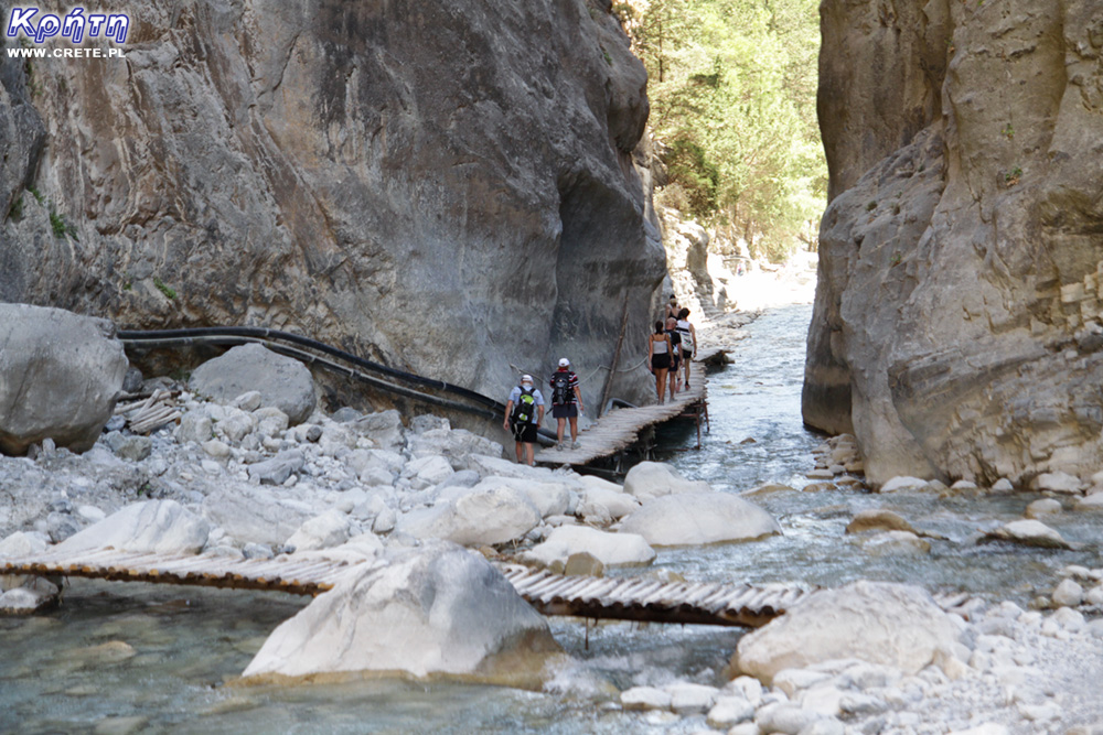
Samaria Gorge This place does not need to be introduced to anyone, because Samaria is the longest gorge in Europe and at the same time one of the greatest attractions of the island. During the season, a lot of coaches come here every day to deliver optional trips. There are also individual tourists. Some people call Samaria ceprostrada, which, however, does not change the fact that it is primarily a beautiful gorge that can give a hard time to people with a lower condition ..
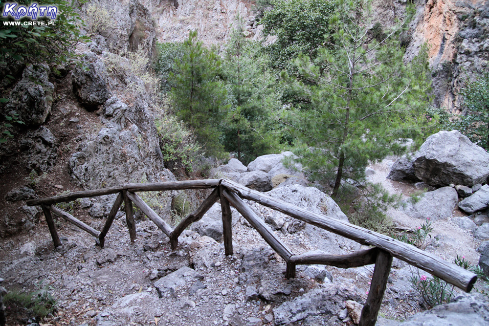
Agia Irini gorge Located almost next to Samaria. This gorge is shorter and easier to walk, and it is not as crowded as Samaria. So if you are in this area and you want to go through a gorge but not necessarily "go down" in Samaria, Agia Irini will be a really nice alternative.
Imbros gorge It is a medium-length, easy-to-walk, but picturesque gorge at the same time. At its narrowest point, its walls create a passage only 1.6 m wide. The total length of the trail is about 8 kilometers, during which the altitude difference is about 600 m.
Diktamos gorge This little-known gorge is located 21 km east of Chania, next to the village of Katochori, and ends 8 km further in the village of Faragi. The hike here is not the easiest one, some places require more attention while walking. But the canyon is picturesque, covered with endemic diktamos plant, which you probably know in the form of tea.
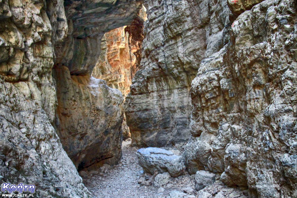
Aradena gorge For many people, the most characteristic place of the gorge is a small bridge connecting the rock walls at a height of about 150 m from the bottom, and the famous ladders. A short distance from the bridge there is an old stone path leading to the bottom of the ravine. The trail that ends at Marmara Beach is rated by some as more interesting than the famous Samaria. Even though the trail itself is not easy, if you like hiking challenges and you already have experience in hiking, it is worth going at least partially while keeping your attention. It is worth being vigilant when defeating it, because many people lose their orientation here and deviate from the path.
Anidri gorge
This is a short but interesting gorge to the east of Paleochora. The most popular descent to it is in the village of Anidri. The gorge ends three kilometers on the lovely Gialiskari Beach. If you stray from the path and follow the red trail, it will lead you through the surrounding hill. Anidri is worth adding to your plans if you spend your vacation in Paleochora or its vicinity.
Other quite popular gorges of this region of Crete are Topolia, Vrissi, Sarakina, Theriso, Avlaki, Kallikratis and Roka.
Walking trail E4 The E4 trail runs through the whole of Crete, but it is its fragment running in this part of Crete that has gained the greatest popularity. In this part of the island, it mostly runs along the shoreline, ending its course in the town of Kastelli near Kissamos. While the passage of the entire E4 within the island is a challenge for several weeks, the passage of selected individual episodes does not require such a large amount of time. The easier sections are
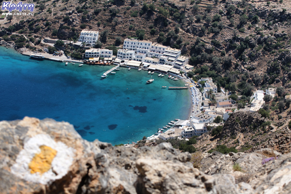
Sick Sfakion-Loutro,
Loutro-Marmara-Agia Roumeli,
Sougia-Lissos,
Lissos-Paleochora,
Krios-Elafonissi
On the other hand, the fragment between Sougia and Agia Roumeli is classified as one of the most demanding and most difficult parts of the E4 trail, which is recommended only for very experienced hikers who are properly prepared for this section and for outdoor camping.
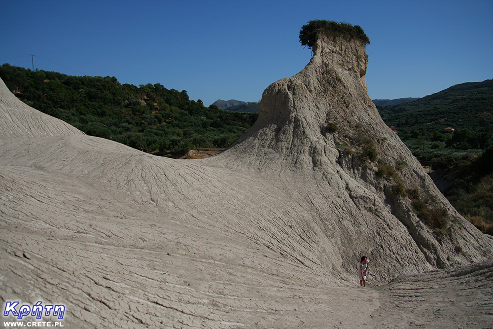
Potamida
In the village of Potamida, there are earth pyramids, known as Greek Cappadocia, which form one of the strangest and most interesting landscapes in Crete. It is not a particularly extensive area and it is rather hard to get tired here, but climbing the clay hills suited us best in the category of attractions for active people.
Od siebie chciałbym dodać, że oprócz opisanej tu wersji nadmorskiej E4 w Górach Białych jest jeszcze wersja górska. Zaczyna sie na płaskowyżu Askifou, w miejscowości Ammodaura przechodzi przez szosę i podchodzi przez schronisko Tavri ( stale zamknięte) na płaskowyż Niato. Dalej prowadzi przez przełęcz Seli, niesamowite miejsce zwane Sideroporti ( pomiędzy dwoma pasmami jest połączenie czymś co przypomina groblę) do Mitato Livadia, jedynego miejsca w Górach Białych gdzie jest stałe źródło wody. Stamtąd prowadzi do Katsivelli i dalej górami do schroniska Kallerghi i dalej na Omalos, a konkretnie do Xiloscalo. Stąd "kanoniczna" wersja prowadzi na przełęcz pod Gigilosem i dalej powoli w dół przez góry do Soughii gdzie łączy się z powrotem z opisaną powyżej wersją nadmorską. Trasa jest piękna, ale nie nadaje się na jednodniową wycieczkę przy okazji pobytu w hotelu - praktycznie wszystkie odcinki są na tyle długie że zajmują przynajmniej 2 dni, a częściej przynajmniej 3 czy 4. Tak więc wymaga to po prostu przyjazdu z nastawieniem się na przynajmniej kilkudniowe przejście przez góry, zabranie maty i śpiwora - wystarczy lekki na +5. W kilku miejscach są schrony, poza tym można zawsze spać pod gwiazdami, które w miejscu gdzie nie ma żadnych świateł są niesamowite. Najlepszym terminem jest maj - w wyższych partiach z reguły jeszcze się da znaleźć plamy śniegu, w razie tragicznej sytuacji z wodą da się pić po stopieniu. Ale bezpieczniej nosić tyle wody ile potrzeba i planować tak trasę by przechodzić przez Livadię lub Roussies gdzie jest cysterna. Bo oprócz E4 jest jeszcze szlak z Katsivelli gdzie można dotrzeć E4 przez Roussies z możliwością podejścia na Pachnes do Annopoli i dalej w dół do Loutro też znakowany i bardzo ładny. No i jak ktoś chce tylko na Pachnes to jest to też realne w jeden dzień - trzeba być wcześnie w Annopoli skąd drogą gruntową na parking na 1900 mnpm i stamtąd 3 - 4 godziny w górę i 3 w dół. W środku lata odradzam chodzenie po górach Białych ( oprócz ew podejścia na Pachnes z parkingu) gdyż jest bardzo gorąco i trzeba nosić dużo wody, a w cysternach może jej już brakować - tam jest woda z wiosennych roztopów. Lepiej już jechać we wrześniu a nawet na początku października.
Planując przejście w maju trzeba mieć jakiś plan B - bo co 2 - 3 lata po mocno śnieżnej zimie potfi leżeć dużo śniegu do początku czerwca.
Gosia | crete.pl
2021-08-25 20:24:20
Tak, faktycznie jest alternatywna górska wersja E4. Wielkie dzięki Piotrze za cenne informacje do tej części.
2021-08-26 12:45:37
komentarz z
Czy rejsy na Balos z Chanii są odwoływane czy odbywają się normalnie?
CRETE - Kreta
2021-08-26 14:10:52
komentarz z
Gosia Bielecka ? Z jakiego powodu odwoływane?
2021-08-26 15:18:58
komentarz z
słyszałam, że chyba był odwoływane z powodu zagrożenia pożarowego ale być może to były tylko plotki. Lecę lada moment na Kretę i chciałabym skorzystać z takiego rejsu
1
CRETE - Kreta
2021-08-26 17:54:50
komentarz z
Gosia Bielecka Tak, ale teraz nie ma zagrożenia na tak wysokim poziomie. Wszystko odbywa się normalnie.
1
2021-08-27 08:04:51
komentarz z
Dziękuję, to dobra wiadomość
Wypełnij poniższy formularz aby dodać komentarz
lub kliknij w poniższy link aby skorzystać z możliwosci komentowania przez facebooka: https://www.facebook.com/crete.poland/posts/10158142027512551
gość PiotrWie Jeździliśmy na Kretę od 2008r, bywały lata że byliśmy w kilku kawałkach w sumie czterdzieści kilka dni ( samoloty z Wrocławia latały w piątek wieczorem tak że można było polecieć po pracy, powrotem był w poniedziałek w nocy więc za 11 dni urlopu można było być 17 dni, jak się zaplanowało z jakimś świętem to można było być 2 x 17 dni i raz 10 dni) i z roku na rok było coraz więcej ludzi - nie tylko na plażach ale ... (...)
Czy wyspa jest w stanie pomieścić 15 mln turystów, zapewne tak. Pytanie moje: skąd będzie woda?! Jak już brakuje, tama na Aposelemis sucha, gdzie ścieki popłyną, gdzie będą składowane śmieci??? Smutne, że wyspa zamienia się na globalną destynację.. rozumiem, że pieniądze są ważne ale żeby dewastować naturalne tereny np.triopetra, plakias etc... przykro
Można próbować zrozumieć ludzi, którzy z tego żyją. Można też puścić ludzi na żywioł i nie zajmować się takimi głupotami, jak ofiary śmiertelne. Samaria nie jest szlakiem w 100% bezpiecznym (który szlak jest), to głęboki wąwóz, narażony na erozyjne osunięcia skał. Poza ty, to jest region aktywny sejsmicznie i dość kapryśny pogodowo.
Myślę, że tu nie ma miejsca na ustępstwa. (...)
gość PiotrWie Dziś po raz pierwszy ( a jeździmy dużo od 2008 roku i dużo chodzimy po szlakach) widzieliśmy w Grecji ekipę przygotowującą szlak do sezonu. Nie była to co prawda zbyt duża ekipa - dwie osoby z motyką, sekatorem i niewielką piłą ręczną - ale zawsze coś - na wyspach Kanaryjskich ekipa to pierwszy z kosą spalinową a zanim kilka osób zmiatających resztki na bok. (...)
 2021-08-24 20:06:05

Komentarze
Od siebie chciałbym dodać, że oprócz opisanej tu wersji nadmorskiej E4 w Górach Białych jest jeszcze wersja górska. Zaczyna sie na płaskowyżu Askifou, w miejscowości Ammodaura przechodzi przez szosę i podchodzi przez schronisko Tavri ( stale zamknięte) na płaskowyż Niato. Dalej prowadzi przez przełęcz Seli, niesamowite miejsce zwane Sideroporti ( pomiędzy dwoma pasmami jest połączenie czymś co przypomina groblę) do Mitato Livadia, jedynego miejsca w Górach Białych gdzie jest stałe źródło wody. Stamtąd prowadzi do Katsivelli i dalej górami do schroniska Kallerghi i dalej na Omalos, a konkretnie do Xiloscalo. Stąd "kanoniczna" wersja prowadzi na przełęcz pod Gigilosem i dalej powoli w dół przez góry do Soughii gdzie łączy się z powrotem z opisaną powyżej wersją nadmorską. Trasa jest piękna, ale nie nadaje się na jednodniową wycieczkę przy okazji pobytu w hotelu - praktycznie wszystkie odcinki są na tyle długie że zajmują przynajmniej 2 dni, a częściej przynajmniej 3 czy 4. Tak więc wymaga to po prostu przyjazdu z nastawieniem się na przynajmniej kilkudniowe przejście przez góry, zabranie maty i śpiwora - wystarczy lekki na +5. W kilku miejscach są schrony, poza tym można zawsze spać pod gwiazdami, które w miejscu gdzie nie ma żadnych świateł są niesamowite. Najlepszym terminem jest maj - w wyższych partiach z reguły jeszcze się da znaleźć plamy śniegu, w razie tragicznej sytuacji z wodą da się pić po stopieniu. Ale bezpieczniej nosić tyle wody ile potrzeba i planować tak trasę by przechodzić przez Livadię lub Roussies gdzie jest cysterna. Bo oprócz E4 jest jeszcze szlak z Katsivelli gdzie można dotrzeć E4 przez Roussies z możliwością podejścia na Pachnes do Annopoli i dalej w dół do Loutro też znakowany i bardzo ładny. No i jak ktoś chce tylko na Pachnes to jest to też realne w jeden dzień - trzeba być wcześnie w Annopoli skąd drogą gruntową na parking na 1900 mnpm i stamtąd 3 - 4 godziny w górę i 3 w dół. W środku lata odradzam chodzenie po górach Białych ( oprócz ew podejścia na Pachnes z parkingu) gdyż jest bardzo gorąco i trzeba nosić dużo wody, a w cysternach może jej już brakować - tam jest woda z wiosennych roztopów. Lepiej już jechać we wrześniu a nawet na początku października.
Planując przejście w maju trzeba mieć jakiś plan B - bo co 2 - 3 lata po mocno śnieżnej zimie potfi leżeć dużo śniegu do początku czerwca.
Tak, faktycznie jest alternatywna górska wersja E4. Wielkie dzięki Piotrze za cenne informacje do tej części.
komentarz z
Czy rejsy na Balos z Chanii są odwoływane czy odbywają się normalnie?
komentarz z
Gosia Bielecka ? Z jakiego powodu odwoływane?
komentarz z
słyszałam, że chyba był odwoływane z powodu zagrożenia pożarowego ale być może to były tylko plotki. Lecę lada moment na Kretę i chciałabym skorzystać z takiego rejsu
komentarz z
Gosia Bielecka Tak, ale teraz nie ma zagrożenia na tak wysokim poziomie. Wszystko odbywa się normalnie.
komentarz z
Dziękuję, to dobra wiadomość
Wypełnij poniższy formularz aby dodać komentarz
lub kliknij w poniższy link aby skorzystać z możliwosci komentowania przez facebooka:
https://www.facebook.com/crete.poland/posts/10158142027512551