Serwis wymaga plików cookies do prawidłowego działania strony. Korzystanie z serwisu bez zmiany ustawień dla plików cookies oznacza, że będą one zapisywane w pamięci urządzenia. Ustawienia te można zmieniać w przeglądarce internetowej.
The best Polish website dedicated to the Greek island Crete and to a small extent of continental Greece. You will find useful information related to visiting Crete that goes beyond the offer of optional tours. On the website you will also find descriptions of the most interesting places that we visited by visiting this largest Greek island. The content complements the current news, photographs and recipes of Greek cuisine.
The European Space Agency (ESA) released this week an impressive photo of Crete taken by one of the European satellites Copernicus Sentinel-1. These satellites are equipped with radars that allow them to "see" through clouds and rain and in the dark. Thanks to this technology, it is possible to photograph the Earth's surface in all conditions. In addition to Crete, the photo also shows smaller islands near Crete: Chrissi, Gavdos, Koufonissi.
Clicking on the above image will open a high quality photo of Crete
gość PiotrWie : Kolejne rekordy to obraz coraz większego overtourismu Krety. Na szczęście są jeszcze miejsca w Grecji gdzie można znaleźć spokój - obecnie jesteśmy na Ikarii gdzie jest mniej więcej tak jak 15 lat temu na południu i w interiorze Krety - na plażach i górskich szlakach spotykasz pojedyncze osoby.
: I bardzo dobrze, Ci wspaniali ludzie zasługują na prosperite.


 2020-11-06 19:52:53
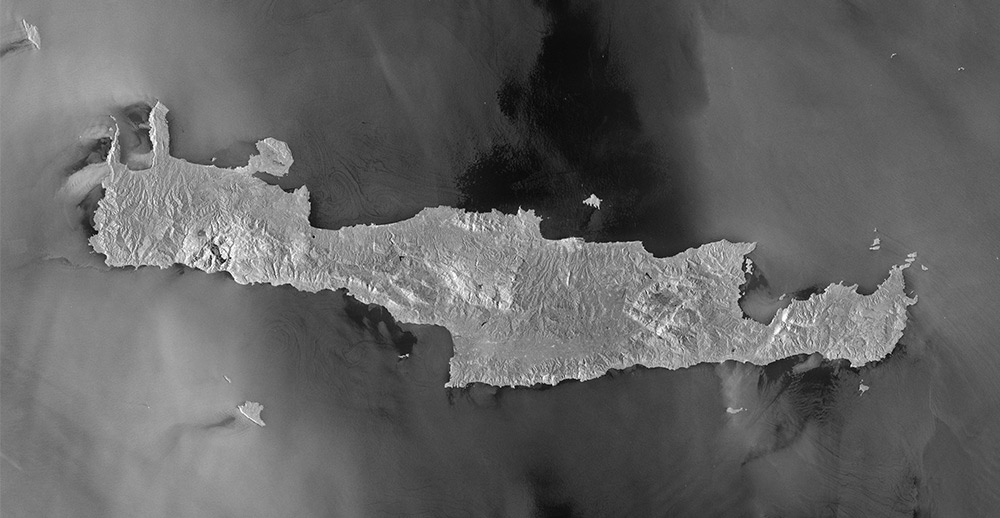


Komentarze
komentarz z
komentarz z
I Copernicus! Z Polski
komentarz z
❤️
Po pobraniu zdjęcia na dysk i powiększeniu super widać wąwozy Krety.
Wypełnij poniższy formularz aby dodać komentarz
lub kliknij w poniższy link aby skorzystać z możliwosci komentowania przez facebooka:
https://www.facebook.com/crete.poland/posts/10157534697532551